1000
1608
1665
1733
1754
1754
1754
1758
1758
1763
1766
1789
1790
1792
1793
1800
1806
1809
1814
1826
1828
1831
1853
1863
1865
1882
1890
1903
1925
1932
1935
1950
1954
1958
1962
1964
1965
1968
1969
1975
1980
1989
1990
1997
1998
1999
2001
2002
2002
2005
2005

Circa 1000 BC. Long before European settlement on the Northwestern shore of the Bay, there were seasonal Algonquin campsites.
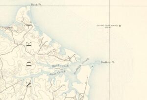
June 1608 - Captain John Smith and a crew of 14 explorers from Jamestown mapped the Magothy River and Bodkin Creek on the first of his two trips to the Northern Bay in 1608.
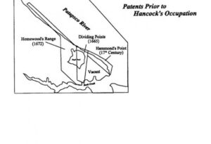
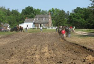
In 1665 David Johnston (a Talbot planter) patented 100 acres known as Dividing Point. Later 35 acres were added and renamed Heirusalem (Fair Jerusalem). The land was farmed (probably with tobacco).

In 1733 William Hancock, Sr. (1680 - 1754) took possession of “Dividing Points” and “Homewood’s Range” by assuming the existing 99-year lease from Wm. Worthington with 96 years remaining on it. William, Sr. moved his family to live on the property, probably on “Homewood’s Range”.
William Hancock, Jr. (3rd generation) began renting 200 acres of “Homewood’s Range” and living on it.
In 1754, William Hancock, Sr. (2nd generation) died.

While living on the Hancock’s earlier property, “Crouch’s Mill Pond” on the Severn River, Stephen Hancock, Sr. (3rd generation) inherited 100 ac. of “Dividing Points” & 100 ac. of “Hammond’s Range” following the death of his step-Mother, Jane. (Date of death unknown - no evidence he ever lived on this property.)
In 1754, Charles Homewood assigned to Thomas Jennings the rights to “Dividing Points”.

In 1758, Thomas Jennings changed the name of “Dividing Points” into “Heirusalem” (the Greek spelling of “Jerusalem”).
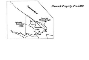
In 1758, Charles Homewood patented “Peggy and Mollie’s Delight” (48 ac.) and assigned the rights to Thomas Jennings.

In 1763, Thomas Jennings won a law suit against Charles Homewood over ownership of the land. Since Homewood no longer owned it, the lease between him and William Hancock became null and void.

Stephen Hancock, Sr. (3rd generation) bought 100 acres of “Heirusalem” and 48 acres of “Peggy and Mollie’s Delight” from Thomas Jennings in 1766.
Stephen Hancock, Jr. (4th generation) mortgaged almost everything he owned to Captain Charles Ridgely of Baltimore for 255 £. in 1789.
In 1790, Stephen Hancock, Jr. (4th generation) purchased 127.5 acres of Homewood’s Range for 255 £.

Stephen Hancock, Jr. (4th generation) resurveyed “Homewood’s Range” in 1792.
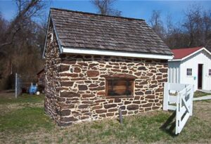
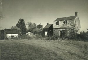
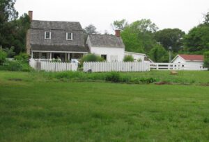
Stephen Hancock, Jr. (4th generation) patented “Homewood’s Range” and 67 acres of vacant land and named it “Hancock’s Resolution”. (Note: the Stone House was already built on “Heirusalem”.
Stephen Hancock, Jr. (4th generation) sold 85 acres of “Hancock’s Resolution” to Francis Hancock (5th generation) in 1800.
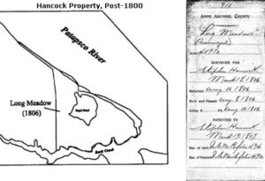
Stephen Hancock, Jr. (4th generation) resurveyed and combined his holdings (1806 to 1807) which, at this time, were 409.5 acres. He named the totality of the farm Long Meadows .
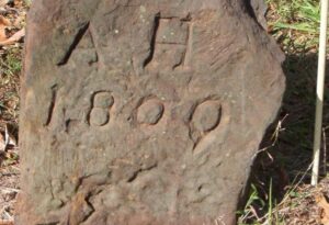
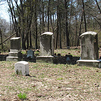
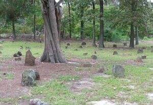
Both Stephen Hancock, Jr. (4th generation) and his third wife, Ann Cromwell, died several months apart in 1809, Stephen going first. Their graves are the oldest legible stones in the Grave Yard.
Francis Hancock (5th Generation) was Captain of his own Company in the 22nd Regiment, Maryland Militia. The Company was active for 17 days in 1814 “near Bodkin”.
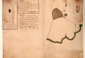
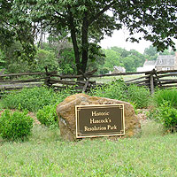
Anne Arundel County created a plat for Hancock's Resolution.
In 1828, Francis Hancock (5th generation) sold 100 acres of “Long Meadows” to his son John (6th generation) including the stone house.
In 1831, Francis Hancock (5th generation) died. Rather than divide up “Long Meadows” among his heirs, Francis provided them with financial support that enabled them to acquire land near his own. (Francis’s younger son, John Wesley Hancock, owned 300 acres near Rock Point (now Ft. Smallwood)). John occupied the Stone House and owned 295.5 acres of “Long Meadows”.
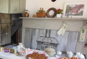
In 1853, John Hancock (6th generation) died. – At his death his eldest son, Henry Alfred (7th generation), took over the rest of the farm (not the part that John bought in 1828). The one and one half story kitchen was added to the stone house in the 1850s.
In 1863, Henry Alfred Hancock (7th generation) conveyed to Benjamin Osborn (married to Caroline Hancock, daughter of Francis) 196.5 acres of Long Meadows (that part which now includes the community of Bayside Beach).
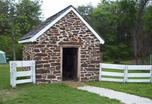
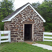
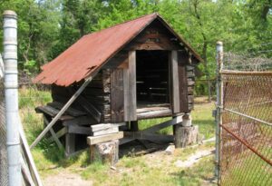
1865 is the approximate date the store was started in the small stone “Milk House” building.
Henry Alfred Hancock (7th generation) purchased the stone house and 100 acres from his family (see “1828” above) in 1882.
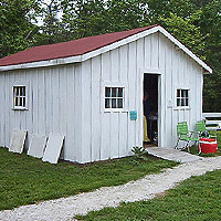
1890 is the approximate date the larger frame store was originally constructed.
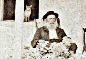
Henry Alfred Hancock (7th generation) died in 1903.

Mathilda Wilkinson Hancock, wife of Henry Alfred Hancock (7th generation), died in 1925.
Hancock’s Store closed in 1932 due to the discontinuation of the daily steamboat service from Fairview to Baltimore.
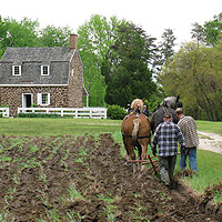
About 1935, farm produce no longer was shipped by boat to the Baltimore market at Long Dock. John Henry Hancock (Harry - 8th generation) continued to grow produce and shipped by truck with the Cooks and Calverts.
In 1950, the 100 acres remaining of the farm were transferred by the heirs of Henry Alfred (7th generation) to the brother and sister John Henry (Harry - 8th generation) and Mary Adeline (Mamie - 8th generation) Hancock.
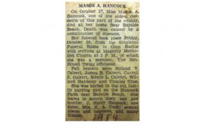
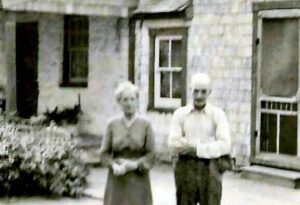
Mary Adeline Hancock (Mamie - 8th generation) died in 1954.
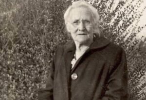
In 1958 Rhoda Virginia Hancock Cook (Ginny - 8th generation) died. Ginny asked her family to preserve the family house and history.
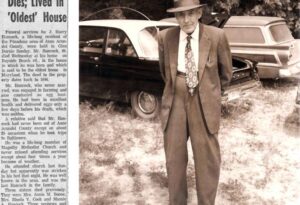
In 1962 John Henry Hancock (Harry - 8th generation) died. The contents of the house were left to sister Rhoda Virginia’s children: Pansy, Tillie, and Philip Cook. The house and 12 acres were left to “Annapolis Historic Society” to be preserved for historic value
In 1964, Edwin Calvert, grandson of Rhoda Virginia Hancock Cook, was named to the Board of Directors to represent the family.
Each year between 1965 through 1967 there were successful open houses.
In 1968 it was decided by the Historic Annapolis Board that open houses created too much liability and should not be continued.
Starting in 1969, lack of outside interest and volunteers left the property vacant and poorly cared for over many years.
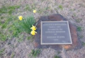
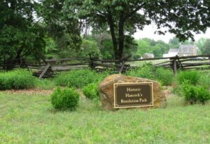
Hancock’s Resolution was listed in the Department of Interior’s National Parks Service’s “National Register of Historic Places” in 1975.
In 1980 "Hancock’s Resolution”: An Historic Structure Report of the Hancock Family Farm was written by Russell Wright A.I.P., A.C.I.P. for the Historic Annapolis Foundation funded by a federal Community Block Grant through Anne Arundel County
In 1989, at the direction of County Executive James Lighthizer, Anne Arundel County Department of Parks and Recreation leased the Hancock property from Historic Annapolis, Inc. for 25 years.
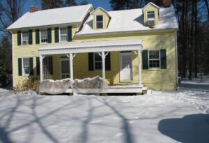
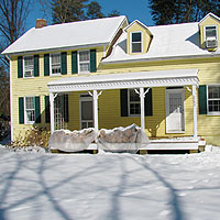
The 1840s – 1850s Cook farmhouse, once belonging to Henry Alfred Cook and Rhoda Virginia Hancock Cook, was moved a mile and a half down Bayside Beach Road to the Hancock farm site in 1990 to be a caretaker’s house.
The Friends of Hancock’s Resolution (FOHR) was incorporated with the intent to preserve, protect and promote the unique historical heritage of the property in the future in 1997.
In 1998, the first $50,000 Grant from Anne Arundel County under Executive John Gary was used for: 1) “conditions assessment” of buildings, 2) a “Level 1” archeological survey of the 14 acres, and 3) a year long “Historic Landscape Analysis” by a professional “ethno botanist”. These formed the core plans for restoration.
In 1999, three grants came in for restoration of the farmhouse and the house site: $150,000 from A.A. County, $150,000 from a State Bond Bill, and $40,000 from Maryland Historical Trust. FOHR contributed another $10,000.
Anne Arundel County, under Executive John Gary, acquired an additional 12.5 acres of adjoining property to expand the available area of the park to 26.5 acres. These additions put the property back on the shore of Bodkin Creek.
The farm was opened to the public in April of 1999 for the first time in 30+ years.
In 2001, Level 1 archaeology was done over the 12.5 acres acquired in 1999. This resulted in a comprehensive archaeological and historical report entitled, “A Plantation in Suburbia” done by Anne Arundel County’s “Lost Towns Project”.
Major restoration work on Hancock’s Resolution was completed in 2002.
The Hancock’s Resolution Foundation began operation to be the home of an endowment fund for Hancock Resolution.
In October a Memorandum of Understanding (MOU) was signed between Anne Arundel County and FOHR under which FOHR assisted the County in planning, maintaining, and operating the Park. This MOU was for one year but with automatic yearly renewals unless terminated by either party. This resulted in the following mission statement for FOHR: “To preserve, protect and promote the unique historic aspects of Hancock’s Resolution for historical and educational purposes.”
Starting in 2003, a $40,000, two years-in-development, Master Interpretation Plan, led by the competitively selected “Cherry Valley Group” of New York, was produced for the County and FOHR. It covered an “Interpretive Vision”, “Interpretive Topics and Themes”, “Overall Program Strategy”, “Evaluation of Resources” available, “Implementation Issues” and “Recommended Timeframe” for the Park.
In the Fall of 2005 there was a major change in ownership when title to Hancock’s Resolution was acquired by Anne Arundel County from the Historic Annapolis Foundation, Inc.
Operation of the Hancock’s Resolution Park has continued as part of Anne Arundel County Parks and Recs until the present time.